
LAND-SEA INTERACTION
The term “Land-Sea Interactions” (LSI) is usually used in the context of planning and management of marine and coastal areas, setting out processes linking terrestrial and marine domains. Such processes may include nutrients and contaminants runoff from agriculture in rivers, and their consequent load in coastal waters, as well as the laying of a submarine pipe to connect an offshore O&G platform to the terrestrial pipeline network. Almost all maritime uses need support installations on land (such as the ports for shipping, marinas for yachting or grid connections for offshore wind farms). On the other hand, there are uses, mostly exerted on the ground (for example, beach tourism, water front, ports), that extend their domain to sea.
Some common categorisations are generally adopted in LSI analysis: i) LSI have double direction: from land toward sea and from sea toward land; ii) LSI can have natural or anthropogenic components.
LSI analysis should also consider the interactions of planning processes and plans for land and sea domains. It is important to ensure that legal, administrative, consultation and technical processes are coordinated (and hopefully linked) to avoid unnecessary duplications, incoherence, conflicts, waste of resources and/or excessive demand of stakeholders’ efforts.
LSI analysis shall be understood as an important component in the preparation of a marine plan. When carrying out MSP, it is important to consider the continuity between land and sea, and to ensure that spatial planning is conducted in an integrated manner across maritime and terrestrial areas. This is of interest for both the environmental protection of coastal areas and the effective development of maritime and coastal economies.
The specific objectives of LSI analysis are:
– Identify and localise most relevant LSI, at present and in the future
– Understand the spatial scope of LSIs and eventually localise hot spot areas
– Identify measures, to be included within the marine spatial plan, aimed at managing impacts/synergies on marine activities and ecosystems, determined by land-sea interactions
Placing Along the MSP Process
LSI analysis should be included from the beginning to the end of the process with focus given in three distinct phases:
1. Context and analysis phase: existing and potential interactions are identified based on the present conditions of the territory and the already planned developments).
2. Analysis of future conditions: when could new interactions emerge (or disappear) due to the planning choices.
3. MSP design phase: actions to manage LSI can be included in the portfolio of measures.
Early engagement to reach a common understanding on the scope and objectives of the process
Identification of LSI
Collection of data on LSI and their spatial extent
Possible contribution to assessment of LSI relevance (on environment, economic sectors, society)
Identification of most relevant LSI (prioritisation)
Identification of recommendations and measures for the MSP plan
Use the step by step diagram to guide LSI analysis within the MSP process. Follow Part A for stocktaking, Part B for in-depth analysis, and Part C for informing the plan.
The guidelines were tested on Mediterranean pilot cases, firstly under the SUPREME and SIMWESTMED projects, and then as part of the MSP processes in Montenegro (GEF Adriatic project), Malta (MSP national Maltese process) and in Italy (MSP national Italian process).
Additional support for cataloguing the interactions and implementing the LSI stocktaking (Part A), along with the user manual, is available in the Planning Tools.
Placing Along the MSP Process
1. Context and analysis phase: existing and potential interactions are identified based on the present conditions of the territory and the already planned developments).
2. Analysis of future conditions: when could new interactions emerge (or disappear) due to the planning choices.
3. MSP design phase: actions to manage LSI can be included in the portfolio of measures.
Active engagement of stakeholders is a crucial component. It is essential that stakeholder engagement in LSI analysis is integrated as much as possible within the MSP. Engagement of stakeholders in the process is key for several aspects and phases of LSI analysis, such as the following:
Early engagement to reach a common understanding on the scope and objectives of the process
Identification of LSI
Collection of data on LSI and their spatial extent
Possible contribution to assessment of LSI relevance (on environment, economic sectors, society)
Identification of most relevant LSI (prioritisation)
Identification of recommendations and measures for the MSP plan
Download the LSI Analysis in MSP – User Manual to guide you through the steps and process.
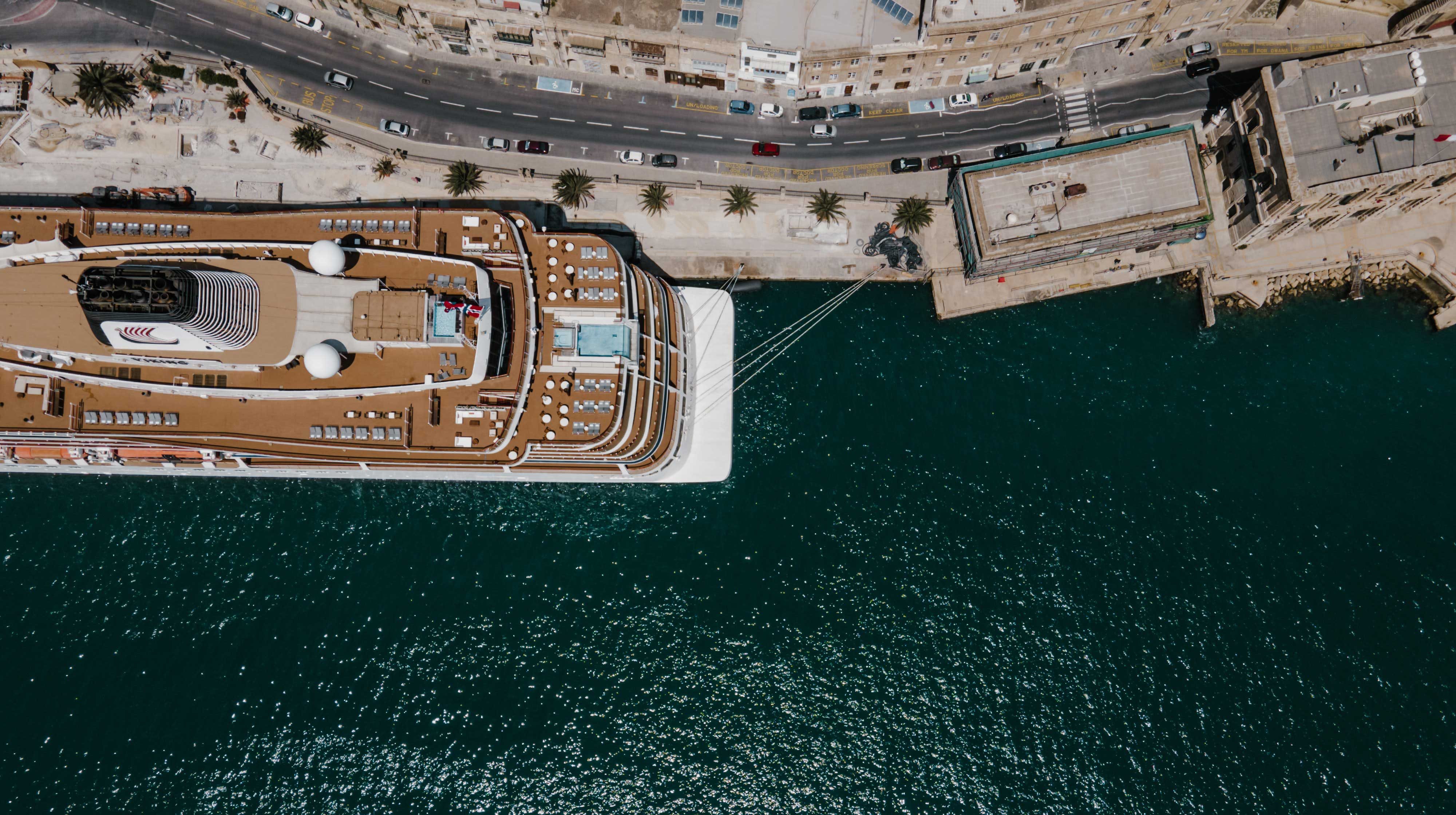
Identification of LSI hot spots in the Maltese islands
The Maritime Spatial Planning (MSP) Directive was transposed into the Maltese legislation in October 2016, through the MSP regulations (S.L. 552.27) which assigned the Strategic Plan for Environment and Development (SPED) as Malta’s Maritime Spatial Plan and delegated the Competent Authority for MSP within the Planning Authority.
The SPED is based on an integrated planning system that regulates the sustainable use and management of land and sea resources. The SPED (i) ensures the sustainable management alongside the protection of the environment; and (ii) guides the development and use of land and sea space.
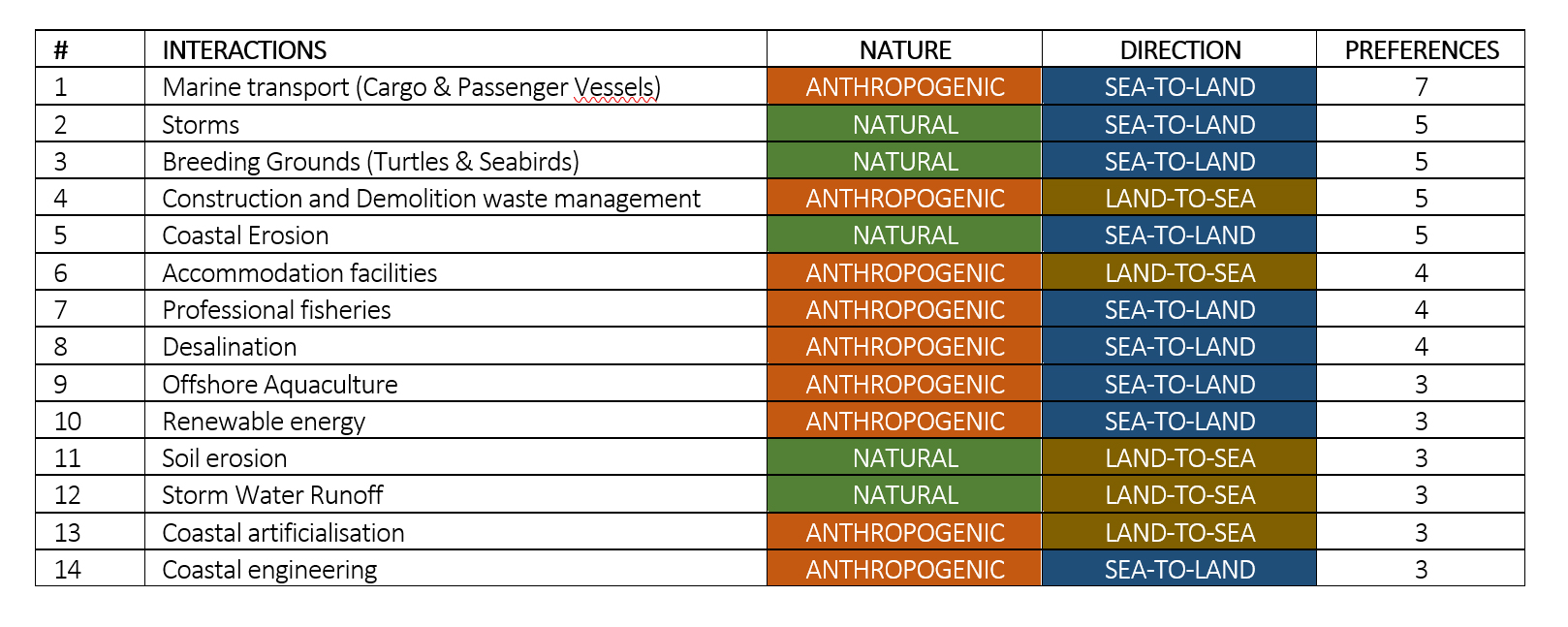
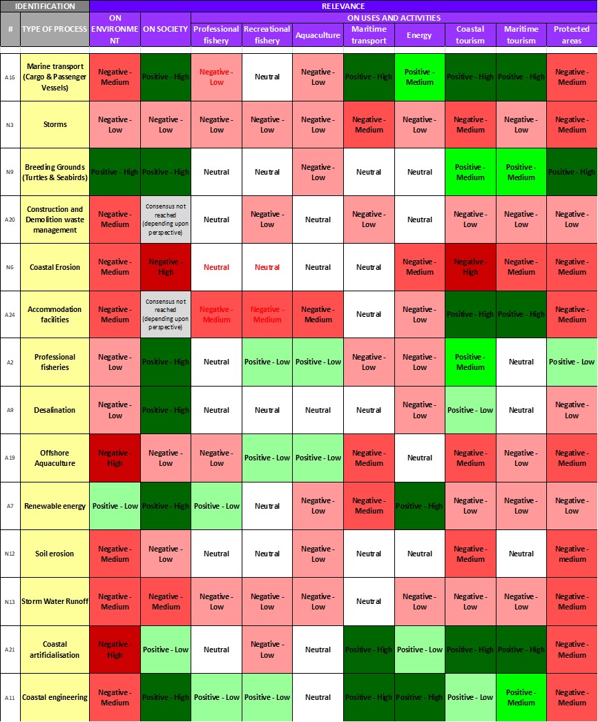
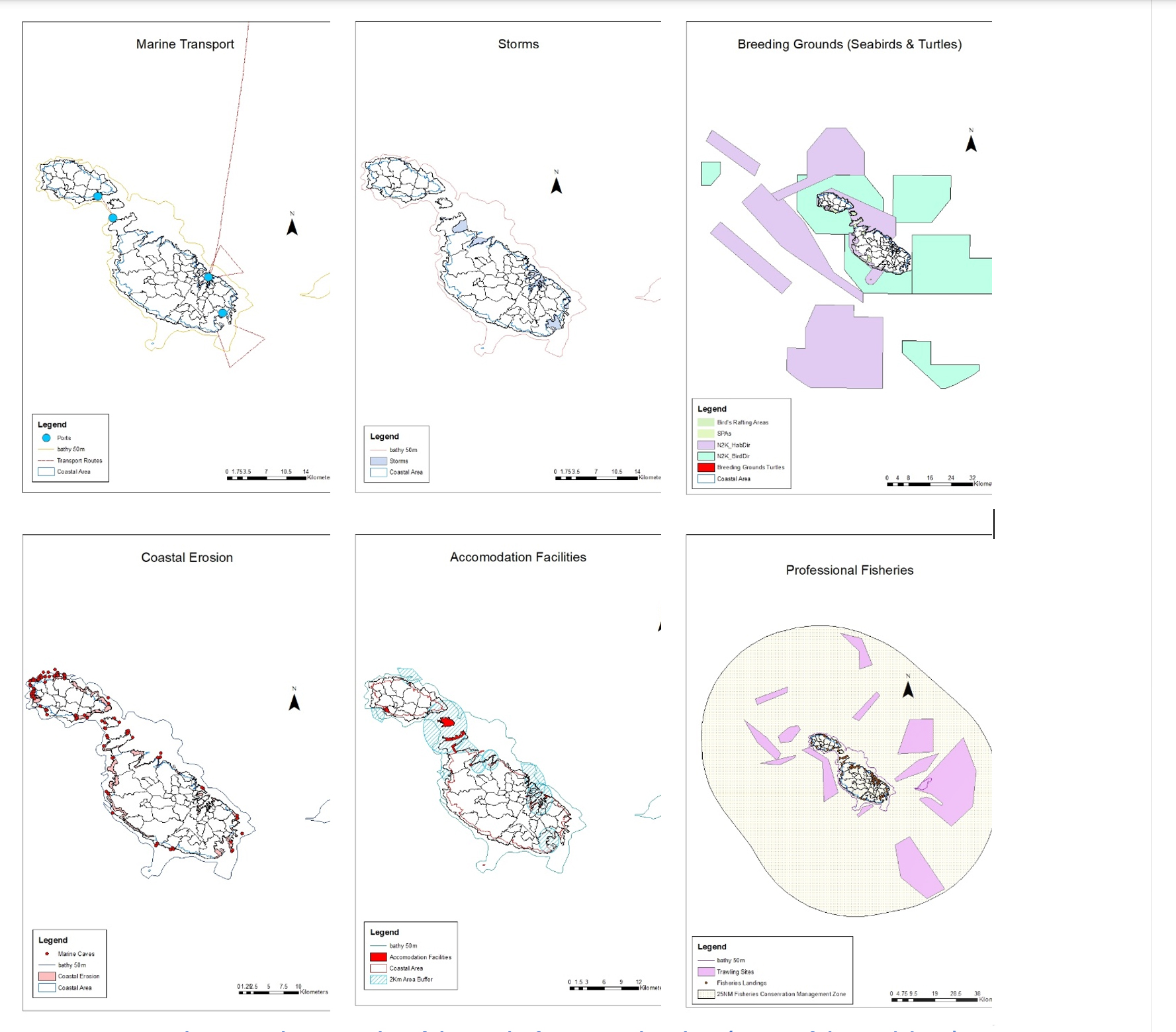
The Guidelines for land-sea interactions (LSI) analysis has been applied in the Maltese context. The analysis considered the scale of the entire Maltese island territory and sea space. Through active engagement of key stakeholders, LSI were identified (36 interactions in total) and located across the entire area of analysis. After selection of the most relevant LSIs (14 interactions selected), their spatial extent was mapped and analysed in further detail. Spatialisation of some key interactions are reported below together with some other results achieved.
-

- LSI in Malta: key selected interactions (Step 8 of the Guidelines)
-

- LSI in Malta: assessment of relevance of interations (Step 4 of the Guidelines)
-
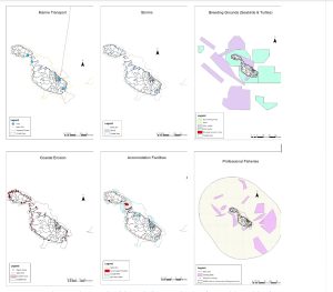
- LSI analysis in Malta: examples of the results from spatial analysis (Step 9 of the Guidelines)
-

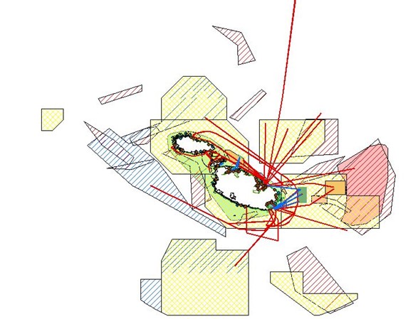
- Spatial distribution of LSI in the Maltese islands: understanding spatial features of LSI and identification of hot-spots (results from Step 3 and 9)
Conceptual process for large marine areas
The EU MSP Directive was transposed in Italian legislation with the Legislative Decree 17 October 2016, n. 201. The Ministry of Infrastructure and Transport is the competent authority for MSP. Italy is preparing three marine plans for the areas under national sovereignty. The plans consider marine space only, from coastlines to the outer borders where Italy exerts its sovereignty. Regarding the scale, due to the vastness of the area to be analysed the national MSP process for LSI analysis has adopted a nested-approach, primarily using a general analysis at marine area scale. Hot spot areas have been identified as a result of the first step and these areas have been then analysed in greater detail, following part A of the Guidelines. The process is still in progress. Some features of the approach are exemplified below.
Examples of factors considered to identify LSI (Step 2)
| Anthropogenic activities on land | Anthropogenic activities at sea | Natural factors |
| • Agricultural and pasture areas • Urbanized areas • Industrial areas • Port areas (including fishing ports, ports used for aquaculture activities, marinas) • Contaminated sites • Outfall of wastewater treatment plants • Protected areas for environment or for cultural heritage protection • Future projects / plans with possible interactions |
• Aeolian fields • Marine areas for O&G exploitation • Marine areas for mining activities • Areas with cables and pipes • Protected areas for environment or for cultural heritage protection |
• Delta / estuary areas relevant for water / solid / polluting supplies • Areas subject to coastal erosion • Areas subject to flooding • Areas subject to saline intrusion |
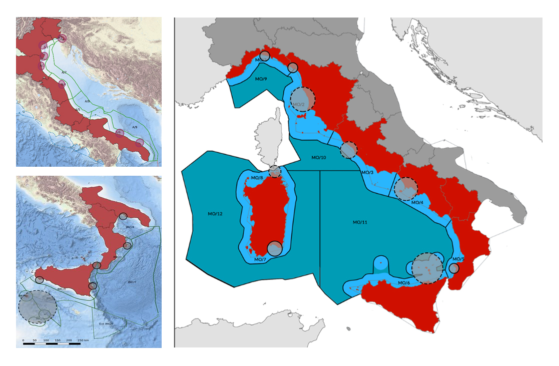 Identification of LSI hot-spots in the three maritime areas of the Italian MSP process (source: MSPMED project, presentation given in the 2nd workshop “LSI analysis for MSP”, 27 October 2020)
Land-sea interactions essential for the MSP in small marine areas
Land-sea interactions in Montenegro have been analysed as part of the project Implementation of the Ecosystem Approach in the Adriatic Sea through Marine Spatial Planning (the GEF Adriatic Project).
The aim of the analyses was to support MSP processes – to provide recommendations towards reducing the negative impacts of the activities that may disrupt natural processes, degrade valuable phenomena or are in conflict with each other.
The analysis shows the great complexity of the coastal area of Montenegro, with a number of relevant land-sea interactions. The intensity of interactions is a result of intensive uses in the narrow coastal and marine area, along with highly valuable and fragile characteristics of the marine environment. The analysis largely confirms the importance of vulnerable areas identified in previous analyses, especially beaches and natural parts of the coast along tourist zones and settlements. It addresses not only the existing interactions, but also the potential/future interactions and areas that should be taken into account in further spatial planning of the coastal and marine area, such as urbanisation, post systems and nature conservation.
The results of the analysis were integrated in the Draft MSP for Montenegro.
Other Tools and Practices
1. Briefing paper of the DG MARE workshop on LSI analysis, June 2017, Malta: including different approaches to LSI.
2. Brochure LSI in MSP.
3. ESPON 2020 project on MSP and LSI, including Croatian and Slovenian case studies.
4. Ongoing application of the SUPREME/SIMWESTMED guideline in the Maltese and Italian MSP.
